Haida Gwaii, BC, Canada
Haida Gwaii Travel & Adventure Guide
( formerly Queen Charlotte Islands )
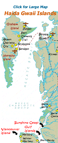
 Click the Community text links on the right or the map to plan your Vacation.
Haida Gwaii, BC, Canada (formerly known as the Queen Charlotte Islands) is an archipelago of 150+ islands located 93 nautical miles (172 kilometres) off the mainland coast of northern British Columbia, Canada. Haida Gwaii is home to beautiful sandy beaches, forests, wildlife and an abundance of First Nation art, culture and tradition.
The two main populated islands of Haida Gwaii are Graham and Moresby Islands. South of the two populated islands is the world famous island called the Gwaii Haanas National Park.
Graham Island is the largest island of the two populated islands. It is the most accessible of the islands comprising of 6 villages - Masset, Old Masset, Port Clements, Tlell, Skidegate, and Queen Charlotte City. Transportation to and from Graham Island is via floatplane or via an 8-10 hour ferry excursion departing from the community of Prince Rupert, British Columbia which is located on the B.C. Mainland.
Moresby Island is home to one village named Sandspit Village. Moresby Island is accessed via floatplane and a ferry departing from Graham Island. Air travel to and from Haida Gwaii is also based out of Sandspit as it is the site of the main airport servicing commercial and charter airplanes.
The islands cover a total distance of 250 kilometres (156 miles) north to south and, at its thickest point, is less than 100 km (52 miles) east to west. Haida Gwaii is the western-most point of Canada and in the language of the First Nation people translates into, "a place of wonder".
When you subscribe to the blog, we will send you an e-mail when there are new updates on the site so you wouldn't miss them.
Comments