Buffalo Pound Provincial Park

Park Size: 1,930 hectares (4769 acres)
Difficulty: Easy - Family
Park Amenities:
( hiking, mountain biking, picnicks, birdwatching, fishing, camping, canoe, kayak, water skiing, jet boating, downhill skiing, snowboarding, xc skiing, ice fishing, snowshoeing )
Buffalo Pound Provincial Park is a popular recreation and wildlife watching destination nestled in the QAppelle Valley located northeast of the community of Moose Jaw, Saskatchewan, Canada. The parkland measures over 1,930 hectares (4769 acres) and was first established in 1963.
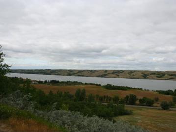
 The provincial park is situated on the shores of a lake and a wetland marsh. The lake is a 35 kilometre long - 2.5 kilometre wide lake named Buffalo Pound Lake. The wetland is a birding sanctuary called the Nicolle Flats Marsh.
During the summer the park is popular for activities and adventures like birdwatching, camping (paid), hiking, sightseeing, canoeing, picnicking, kayaking, mountain biking, swimming, water skiing, wake boarding and fishing for pike, perch and walleye.
During the winter the White Track Ski Hill area in the park is popular for activities and adventures like cross country skiing, downhill skiing, snowboarding and snowshoeing... while the Buffalo Pound Lake is still popular for fishing but now it is ice fishing.
There are many paid campgrounds in the park providing hundreds of campsites during the summer months - many full service and some tenting. There are two sandy beaches on Buffalo Pound Lake near the Elmview and Maple Vale camping sections of the park.
Services and amenities located throughout the Moose Jaw, Saskatchewan park include playgrounds, boat launch, picnic areas, heated outdoor pool, fish fillet building, washrooms, park office, stocked trout pond, sani dump, store, concession, general store, mini golf and recreation trails.
In the summer the White Track Ski Hill is the site of over 30+ kilometres of mountain biking trails and gravel roads, both challenging and casual. And southeast of the hill is the Nicolle Flats Marsh which is the site of some sightseeing hiking trails and birdwatching lookouts.
Nicolle Flats Marsh is a prime birding site near the confluence of the Moose Jaw and Qu'Appelle Rivers. The marsh is an oxbow wetland environment dominated by cattails, high grasses, water insects and birds.
There are many waterfowl, predator and song birds sighted in the park. Some sightings include red-tailed hawks, ducks, geese, mountain bluebirds, lark sparrows, coots, grebes, great blue herons, belted kingfishers and spotted sandpipers.
It is not just hiking trails and birdwatching at the Nicolle Flats Marsh - the marsh is also the site of the Bison Viewing Tower, a natural spring, the Nicolle Heritage Homestead and the (TCT) Trans Canada Trail.
The hiking trails located near the Nicolle Flats Marsh are best accessed from two points - an east and west trailhead. The Nicolle Homestead Parking Lot (east) provides access to the Valley, Nicolle Flats, TCT and Dyke Trails. The Buffalo Viewing Tower (west) provides access to the Bison View, Marsh Boardwalk and the Nicolle Flats Trails.
Dyke Trail is a one way trail measuring 4.5 km long and is part of the TCT (Trans Canada Trail). The elevated dyke trail follows the north shore of the Nicolle Flats Marsh and the banks of the Moose Jaw and Qu'Appelle Rivers. A short 200 metre trail leads to the confluence of the rivers and an old cable car and water station.
Nicolle Flats Trail is a one way trail measuring 3 km long. The trail follows the south shore of the Nicolle Flats Marsh between the Buffalo Viewing Tower and the Nicolle Homestead. It is the one trail which connects the two parking lot trailheads in the Nicolle Flats Marsh area of the Buffalo Pound Provincial Park.
Valley Interpretive Trail is a loop trail measuring 1.5 km long with interpretive numbered posts matching an informational brochure. The trail follows the Moose Jaw River exploring a wetland area before connecting with sightseeing benches, viewing blinds and platforms. The trail connects to the Dyke Trail on the north end.
Bison View Interpretive Trail is a one way trail measuring 3 km long following the bison paddock fence up to the top of a hill and some sightseeing benches. There is a lookout tower near the starting trailhead providing possible views of the local buffalo herd.
Marsh Boardwalk Trail is a one-way birdwatching trail measuring a 1/2 km long. Surrounded by cat tails and tall grasses, the trail follows a floating wooden boardwalk out onto the Nicolle Flats Marsh leading to a viewing area. Good for birdwatching!
Address:

